
To work as a surveyor in the ACT, there are many different types of survey marks you should be aware of. Find them below with a brief description of each.
Identifier – district names, old surveyors’ names (e.g. Tennent, Goodwin)
Trigonometrical Stations (Trigs)
Generally consist of a ground mark with a quadripod above the ground mark. Most Trigs were part of the ACT Precision Zone, which in turn formed part of the national geodetic survey and adjustment for the Australian Geodetic Datum 1966 (AGD66). The ACT Precision Zone and its associated marks have been the primary survey control for all new development in the ACT since the early 1970s. The accuracy of ACT Precision Zone marks is 1 in 250,000 with respect to AGD66. In the early 1990s, 40 of the Precision Zone Trigs were surveyed with geodetic quality GPS observations as part of the GDA94. More recently, all the ACT trigonometrical network was re-surveyed with geodetic quality Global Navigation Satellite Systems (GNSS) observations for inclusion in the GDA2020 national adjustment.
Continuously Operating GNSS Reference Stations (CORS)
In partnership with NSW DCS Spatial Services, OSGLI has established a network of permanent GNSS tracking stations which form part of CORSnet-NSW. This network is a key component of GDA2020 and provides centimetre-level real-time positioning for a range of scientific and spatial industry purposes. SGC values were also established on each CORS from the passive trigonometrical network.


Identifier – two alpha plus numerals (e.g. ST61)
These marks are fixed directly from the ACT Precision Zone at approximately one-kilometre intervals. They usually consist of a deep driven rod protected by yellow timber or concrete posts. Some SC marks are beaconed (e.g. YA90, TG84). The accuracy of Sectional Control marks is 1 in 100,000.

Identifier – SRM plus numerals (e.g. SRM363)
These marks are coordinated from Sectional Control at intervals of between 200m and 1000m. They usually consist of a galvanised pipe set in concrete or a galvanised star picket with a concrete collar and protected by two steel droppers, painted red and white. There may be an aluminium tag with the mark's identifier either set in the concrete of the mark or wired to one of the steel droppers. SRM identifiers greater than 1000 consist of DH&Ws with an accompanying aluminium tag with the mark's identifier. The accuracy of SRM control is 1 in 30,000.
The subdivisions in Woden Valley (early 1960s) were the first to have SRM control. In suburbs constructed before Gungahlin (pre-1990), SRMs were 50m to 100m apart. Some of these marks survived development and can be found in open spaces in the suburbs. Only those SRMs established since the 1990s have been entered in the survey control mark database ‘Control Base’. Information on earlier SRMs is contained on control plans.

Identifier – CRM plus numerals (e.g. CRM7381)
In today's subdivisions, numbered CRM plaques are generally placed in the kerb and coordinated by survey networks that include Sectional Control, Subdivisional Control marks or other previously coordinated CRMs/SRs. These marks are positioned up to 200m apart.
The early style (flat) CRMs do not have a height attributed to them (e.g. CRMs numbered 1 to 9999). Since April 1998, a new style of CRM is used that has a raised nipple for accurate levelling. These are numbered from 10,001 onwards.


Identifier – SR plus numerals (e.g. SR1691)
SR marks are placed in new subdivisions, one for every 100 blocks. The mark consists of a deep driven steel rod contained within a steel cover box marked "SURVEY MARK". These SRs are coordinated as part of the CRM network. Not all SR marks are levelled. Conversely, some SRs have been levelled, but are yet to be surveyed with accurate horizontal coordinates.

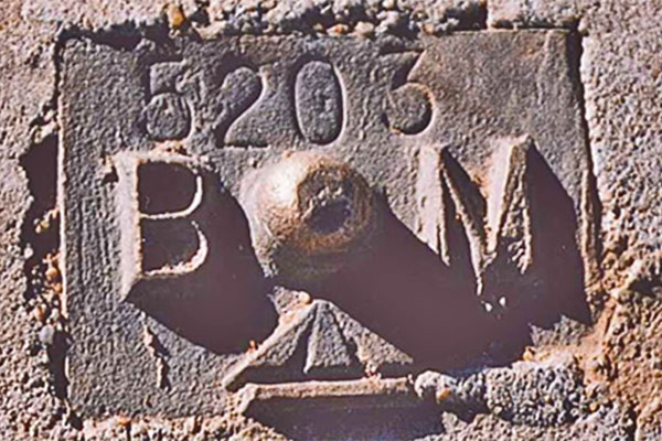
Identifier – KBM plus numerals (e.g KBM5203)
Kerb Bench Marks were placed in concrete kerbs throughout urban Canberra prior to April 1998. They consist of a rectangular brass casting with a nipple and stamped number and were generally levelled to Class LC Order L3 standard of accuracy. (Note: many kerbs have moved over time and differences of more than 0.03m have been found). All KBM reduced levels are on the Australian Height Datum 1971 (AHD71). Since 1998, new style CRMs are placed instead of KBMs.
Precise Bench Marks (PBMs) are generally buried precast concrete blocks that were part of an imperial levelling network on an early Canberra datum known as Precise Datum. Refer to A Short History of Heights in the ACT (2022) [772.3 KB] for information to convert imperial heights (feet) to AHD71 (metres). PBMs are listed as KBMs in ACTmapi (e.g. PBM13 is KBM13 in ACTmapi).
Identifier – R plus numerals (e.g. R804)
Rural Bench Marks were placed in the 1960s and 1970s, at half mile (approx. 800 m) intervals, along many roads in the ACT and surrounding NSW as supplementary levelling to the AHD. They usually consist of a star-iron picket driven to its full length into the ground and surrounded by a concrete collar containing a brass plaque with the mark's identifier. One yellow concrete post may be protecting it. Many of these marks have been coordinated by GNSS surveys. Other Rural Bench Marks exist with identifiers "P", "NE", "NW" and "C".


Identifier – Alphas plus numerals (e.g. GCP27)
Photo Control marks may consist of a GI Pipe in concrete protected by a timber post painted red and white. More recently, Photo Control Marks may also consist of DH&Ws in a concrete structures, such as a footpath, with painted wings. Many older Photo Control marks are for "level only" and their accuracy depends on the scale of the photography they are controlling.


Identifier – Three alphas, starting at AAA (e.g. FFC)
Alpha Marks usually consists of a GI Pipe in concrete protected by two steel droppers. They are placed as a control mark for a specific survey, usually an engineering survey. The accuracy of these marks depends on the nature of the survey they are controlling. Many are of an accuracy that does not warrant nominating the ACT coordinate system.
Identifier – Main mark it recovers, plus RM, plus numerals (e.g. Painter RM2)
Recovery Marks are placed as supplementary control to high-order marks such as trigonometrical stations. Alternatively, Recovery Marks may be identified with “ECCE” (i.e. a mark eccentric to the main mark).
Identifier – Not specified
Miscellaneous marks are any mark not contained in the previous categories. Some examples are old radial blocks (e.g. RA18), Control Marks placed before Sectional Control series commenced, dam deformation marks (e.g. P05) and towers (e.g. BLACK MOUNTAIN TOWER), etc.
Contact us
The Survey Office is part of the Office of the Surveyor-General and Land Information (OSGLI).
Email: actplasurvey@act.gov.au
